![]()
66710 Hwy 60
(PO Box 700)
Salome, Arizona 85348
Phone: (928) 859-3846
Email: mcmullencoc@tds.net
Providing online information for the communities of the Arizona Outback
since 1997 ... www.AZOutback.net


HARQUAHALA PACK TRAIL
(Near Salome, Arizona)
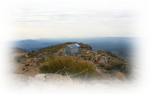
The Harquahala Pack Trail was built in the 1920’s to supply the people who lived at the Observatory. This trail takes you to the 5,681 foot summit of the Harquahala Mountains which is the highest peak in southwestern Arizona. The trail is well maintained and is easy to follow. The last portion of the trail is a leg burner, climbing more than 1,400 feet in 0.75 miles. Do not attempt this trail in the summer where temperatures of 100 plus degrees are the norm. At the summit, along with the panoramic views, you will see the historic observatory built by the Smithsonian Institution in 1920.
Base Camp Trailhead is at an elevation of 2,230 feed, and the Summit Trailhead is at 5,618 feet.
It is 5.4 miles from Base Camp to the Summit, with an elevation gain of 3,361 feet. It is rated difficult and not well marked.
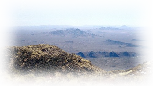
Harquahala Mountain hold both the distinctions of being South Western Arizona’s highest peak and La Paz County’s highest summit. This mountain rises about 3,360 feet from the desert floor. On a good day the views can be extraordinary.
View South from Eagle Head Mountain
GETTING THERE
Lat/Lon: 33.81280°N / 113.3489°W
1. From Salome, turn right onto Highway 60.
2. The dirt road to the trail head is located on the south side of Highway 60 between mileposts 70 and 71.
The road is rather inconspicuous, but is marked by a lone palm tree on the north side of the highway. There is nothing marking this road on the south side of the road so be sure to look for the palm tree.
3. Turn south on this small & somewhat bumpy dirt road and drive through the gate.
4. Immediately past the gate stay to the right,
5. Remain to the left at any branches as you drive the remaining 2.1 miles to the end of the road.
This is a high clearance road only.
HARQUAHALA PEAK SMITHSONIAN SOLAR OBSERVATORY
(Near Salome, Arizona)
Lat/Lon: 33 48.717°N / 113 20.828°W
The Harquahala (originally spelled Harqua Hala) Peak Observatory was at it’s height of glory in 1924. What remains of the field station can be seen first hand by traveling from Eagle Eye Road, up the south side of the mountain, to the peak of the Harquahala Mountains, at an elevation of almost 6,000 feet.
In the late 1800’s Dr. Samuel Peirpont Langley believed the sun caused changes in the climate of the earth. He thought that by measuring these changes (dubbed the “solar constant”) scientists could predict climate events. Dr. Charles G. Abbot, Langley’s protégé, pursued his theory, Harquahala Observatory was built, and testing began. No telescopes were used here. First, a coelostat reflected sunbeams into the observing chamber. A theodolite was then used to measure the sun’s altitude above the horizon; a pyranometer measured heat from the atmosphere around the sun; and two pyrheliometers measured heat from both the sun’s direct rays and scattered rays.
The scientist would then spend many more hours gathering these measurements and mathematically calculating the data by hand. Reports were sent to the Smithsonian Institution in Washington, D.C. so that data from remote observation stations around the world could be compared.
In recent years the Bureau of Land Management has refurbished the Observatory and made improvements to the road, as well as adding signs and restrooms at the base of the trail. Even with these improvements, the road is steep and treacherous and it is recommended for high-clearance 4-wheel drive vehicles with experienced drivers only. The panoramic and breathtaking view from southwest Arizona’s highest point, is well worth the trip.
Satisfying the Observatory's Basic Needs.
Food – Scientists hauled food, water, supplies and equipment up the mountain weekly on pack animals. Their closest neighbor, William Ellison, helped by providing the use of his animals, assisting with pack trail maintenance, and sharing his fresh homegrown vegetables.
Water – The closest water source was located over a mile away and 1,000 feel below the summit. Many times the scientist had to haul it up themselves! Cisterns were soon constructed to collect rain water which they called the “Mt. Harqua Hala Water Works”.
Shelter – The building was designed to serve the needs of the observers and the equipment. The upper level served as kitchen, office, and sleeping quarters and the lower level housed the delicate equipment. Comforts included a wood burning stove, a Kelvinator refrigerator and a shower bath in the workshop.
For More Information
HARQUAHALA MOUNTAINS WILDERNESS AREA
Different from many Sonoran Desert mountain ranges, the Harquahalas (22,880 acres) contain a screened interior canyon system. The distinctive ecosystems provide exceptional natural diversity, including interior chaparrals, desert grasslands and rare cactus populations. The area also supports habitat for desert bighorn sheep, desert tortoise and mule deer populations. Access the northern boundary by jeep trails along Highway 60, east of Wenden. Numerous off-road trails can be found to the south, off Eagle Eye Road. 4-wheel drive vehicles are recommended if you venture off Eagle Eye Road.
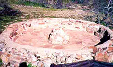
'Arrastra' used to grind ore
OLD MINING DAYS
(photo submitted by Linda Darland)
The "ARRASTRA" was used to grind small pieces of ore by using a very large boulder on the inside perimeter that was pulled by mules or donkeys around the outside perimeter. The hub in the center of the ARRASTRA has shafts that allows ropes, rods, cables to be hooked up. This Arrastra was found in the Harquahala Mtns in pristine condition near an old cabin and mine shaft.