![]()
66710 Hwy 60
(PO Box 700)
Salome, Arizona 85348
Phone: (928) 859-3846
Email: mcmullencoc@tds.net
Providing online information for the communities of the Arizona Outback
since 1997 ... www.AZOutback.net


HARCUVAR MOUNTAINS
The 25,050-acre Harcuvar Mountains Wilderness is in northeast La Paz County 82 miles northwest of Phoenix, Arizona. The Harcuvar Mountains are a narrow mountain range in western-central Arizona. The range lies just east of the north-south Colorado River, and south of the east-west, west-flowing Bill Williams River. They rise abruptly from the desert floor with over 10 miles of its rugged ridgeline within the wilderness. Elevations range from 2,400 feet on the bajadas to over 5,100 feet along parts of the mountainous crest. The range is part of the three-range sequence of mildly arc-shaped ranges and two intermountain valleys in the Maria fold and thrust belt, a region in western Arizona and southeast southern California, with the Colorado River flowing south through the western part of the belt. The fold-and-thrust-belt region contains numerous plains, valleys, and mountain ranges about 30 landforms in all. The range is a narrow range about 25 miles long and 5 miles wide, and trends southwest to northeast.
The McMullen Valley is the southeast border of the range, and is traversed by US Route 60. Four peaks are found in the range, the highest peak is Smith Peak, Arizona, 5,242 feet in the northeast, but not easy accessible by road. In the southwest, is Harcuvar Peak, at 4,618 feet. Accessible by unimproved road, via Cottonwood Pass.
Two other peaks lie in the center of the range, one lies adjacent and north of Cunningham Pass, called ECC Peak, at 3,000 feet, and further northeast, ECP peak, at 4,593 feet.
One of the most important aspects of the Harcuvar Mountains is the major, and southern access route to Alamo Lake State Park approximately 30 miles upriver on the Bill Williams River. It begins at Wenden, Arizona and immediately climbs through the Harcuvars to Cunningham Pass. Another 24 miles traverses the Butler Valley’s northeast, and the flatlands northeast of the Buckskin Mountains.
The entire southeast perimeter of the Harcuvar Mountains borders the McMullen Valley, with US Route 60, The series of communities starting at the southwest are Vicksburg, Hope & Harcuvar, then Salome, Wenden and lastly after 26 miles straight stretch, Aguila.
The wilderness area's diverse landforms and plant communities provide habitat for abundant wildlife, including desert bighorn sheep, desert tortoise, cougars, golden eagles, and various hawks. An isolated 3,500-acre "island" of interior chaparral habitat on the northern ridgeline provides homes to several species of wildlife cut off from their parent populations, such as rosy boas, Gilbert's skinks, and desert night lizards.
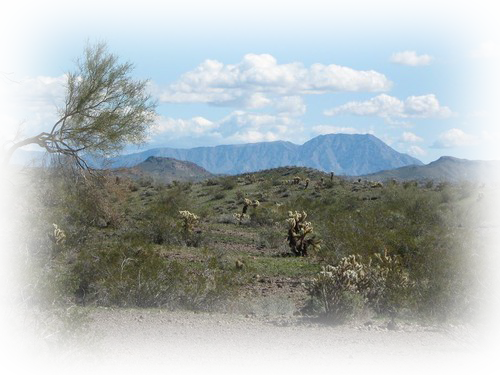
Harcuvar Peak viewed from Swansea Rd
HARCUVAR PEAK
Harcuvar Peak is a major summit located in the Harcuvar Mountains of western Arizona, overlooking the towns of Wenden and Salome along US-60 in the McMullen Valley. The peak has an obvious anvil shape to it, its summit ridge appearing as a flattened top as viewed from below. It is one of two highly-prominent mountains in the Harcuvar Range, the other being the range highpoint, Smith Peak. Whereas Smith Peak can be hiked via a jeep road, no such options exist for Harcuvar Peak. One must contend with rough desert tracks and steep, rocky slopes to attain this summit. However, the climbing is short and straight-forward, and the effort is well worth it.
Relatively few people hike Harcuvar Peak. It is remote from the big cities, and the road net to get to its base is not entirely obvious, forcing one to drive through farms along canal frontage roads and rough, sandy desert tracks. A sturdy vehicle, 4-wheel drive preferred, is needed to get close to the base. The hike itself is a combination of jeep paths and some hefty uphill cross-country hiking. The summit ridge features four potential highest points, all easily visited and all with excellent views. Because of its isolation, the Harcuvar Mountains Wilderness offers outstanding opportunities for wilderness recreation and solitude. The canyons and ridgelines provide an excellent setting for hiking, backpacking, hunting and climbing.
Best time to Hike
The hike is fairly easy: hike north along the track, but don't go all the way to the saddle. Instead, you want to aim for a steep southeast-trending ridge that comes off the peak toward the road.
The round trip covers about 5 miles total and about 2,400 feet of gain. You want to wear long pants, sleeves, gloves and have trekking poles or a staff for the steep sections.
The best times to hike are the cooler winter months from November to March. It gets hot fast here, and summers bake at typically 105-115 degrees F.
How To Get There
Lat/Lon: 33.91640°N / 113.6408°W
Start in Wenden,
1. Turn north onto Alamo Road, and zero the odometer at the railroad tracks.
2. Go north 1.4 mile, then ease left (west) diagonally onto a road that soon fronts a canal. This road would be on the 71 1/2-alignment, but it is unmarked.
3. On the topographical map, it is shown opposite a well at BM-1916.
4. Go west on this canal frontage road for 1.6 miles to where the farm fields end.
5. Continue straight (west) another two miles to a fence corner at spot elevation 2027 on the topographical map. Another road meets this road coming from the south.
6. Turn right and pass north through a gate.
Beware that there may be a berm up to a foot high that needs to be driven over.
7. Drive north one mile to spot elevation 2089. Ignore other tracks that cross this road.
8. Ease slightly left (northwest) and continue up the rough desert track. It comes to a 4-way intersection with another track just east of the Doland Mine.
9. Go straight (slightly east) through this 4-way and park wherever you feel comfortable.
The road drops into a canyon here and becomes very rough, nearly impassable. Up to here, high-clearance should be sufficient to handle the roads, 4-wheel drive a nice option. The roads are sandy in places. In wet weather, beware of mud especially near the farm fields.
 PROUD PARTNERS
Taking advantage of partnering with Logo Branding members can also select this option:
What You Get:
BOLD listing in Directory and AZoutback website ... PLUS a link to your web page, PLUS your hyperlinked logo with your listing and at the bottom of each page of website

![]()
![]()


![]()